Tuba City Dinosaur Tracks visit

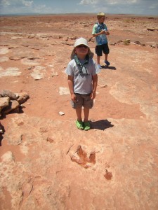
Toby, posing behind a fossilized dino print.

Toby, posing behind a fossilized dino print.

Hwy 160
Moenkopi, AZ

At the Tuba City Dinosaur Tracks, located remotely in the Arizona desert, it’s possible to view fossilized dinosaur tracks. Before stopping there recently on a long road trip, I had read mixed reviews (both concerning the validity of the tracks and the expertise of the local hosts of the site). After visiting, I’d have to guess that both good and bad are well-founded, because one’s experience can vary greatly.

Tuba City Dinosaur Tracks visit:

Located near the Four Corners area within the Navajo Nation, the attraction is not flashy. In fact, I wouldn’t even call it an attraction. If you don’t know what you’re looking for, the single handmade sign directing you off Highway 160 isn’t likely to catch your attention. Out in the middle of the acrid desert, you drive down about 100 yards to a dusty parking lot, where a representative of the Navajo lands (remember, we’re on their property) will greet you and tour you through a series of fossilized prints from the Jurassic period.
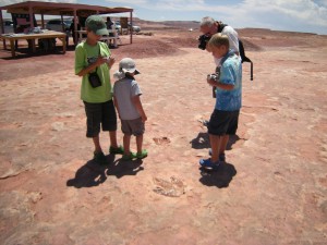
Studying a track. The July heat kept our visit short!

Studying a track. The July heat kept our visit short!

Notice I said Navajo representative’, not guide’. The protectors of this resource are not experts, nor do they claim to be. Our representative, who told us he was a full blood Navajo who had lived his whole life just half a mile from the site, was enthusiastic, friendly toward the kids, but couldn’t answer even my ten-year-old’s questions regarding the dinosaur prints with any certainly. Of course, such unreliable information makes you wonder about the legitimacy of the attraction, but according to my research in garnering additional reviews, paleontologists stress that it’s the real deal: the tracks easily visible all over the immediate area date back 200 million years.

After that, however, all bets are off: one representative claimed tracks from dinosaurs in completely different periods, and ours boasted a T-Rex print (which my prior research had refuted). But apparently, that’s not always the case. Other people have reported far more positive experiences, having enjoyed tours from Navajo representatives who were very well-versed in their subject matter, and had taken the time to round out their knowledge with inquiries to the University of Arizona. It seems to be the luck of the draw.

Either way, it was worth the stop. Dinosaur prints are pretty cool, no matter how you slice it.

Date last visited: July 2009

Distance off the interstate: Just a few yards!

Hours and Admission Prices: Payment is by tip only. When we went, we decided (before arriving) to tip $5 per person, and considered this to be compensation not for expert opinion, but for the privilege of enjoying the Navajo lands. Open every day except most holidays. On slow days, they may close up shop early. Weekends are busiest.

Bathrooms: No.

Food Services: None. Navajo jewelry vendors are usually present, however.

Website: None. You can find more reviews on Google, however.

Directions: From Flagstaff: Take Highway 89 North, then turn right on 160 toward Tuba City. The location of the village of Moenkopi, and the Dinosaur Tracks site are about a mile on the left. This is 5 miles West of Tuba City, not East, on 160.

Reed Bingham State Park

542 Reed Bingham Road
Adel , GA

Not quite ready to let go of summer? Reed Bingham State Park “is about three and a half hours from Atlanta…if camping isn’t your thing, it’s also a good place to just get off the road for a bit to stretch your legs, enjoy a picnic or even squeeze in a game of mini-golf. In addition to mini-golf, Reed Bingham has a nice playground, beach and boat docks. They also rent bicycles and canoes and offer pontoon boat tours. It’s an excellent place for bird watching or learning more about the resident gopher tortoises. The park staff rehabilitates various animals that are orphaned or left on the property. We were lucky enough to see a hummingbird, bluebird, red-headed woodpecker and even a bobcat kitten!”

Review courtesy of Sue from Field Trips with Sue.

Date last visited: August 2009

Distance off the interstate: Less than 6 miles off I-75.

Hours and Admission Prices: $5 park entrance fee per car (camping fees start at $23)

Website: Reed Bingham State Park

Directions: 6 miles west of Adel on Ga. Hwy. 37 via I-75 exit #39, and 14 miles east of Moultrie from U.S. Hwy. 319.

Alfred B. Maclay Gardens State Park

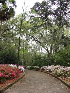
Brick path leading to the Maclay house. Photo courtesy of Florida State Parks.

Brick path leading to the Maclay house. Photo courtesy of Florida State Parks.

3540 Thomasville Rd
Tallahassee, FL

Alfred B. Maclay Gardens State Park is a wonderful place to get out and stretch your legs during a long trip. During blooming season, flowers paint the walk with beautiful colors and during the off season you can see every shade of green, says Jennifer of Two Kids and a Map, who brings us this review. I was on a road trip from Pensacola to Jacksonville, Florida with my two children by myself and we desperately needed a pit stop! The kids were getting hungry and anxious and I was tired of listening to the whining. Unfortunately, the exit I chose is awful for quick interstate stops. There are several lanes of traffic and it is difficult to turn around to get back on the Interstate. I spotted the trademark Florida State Park sign and followed it to the entrance. It was a perfect stopping place for us. The children got to run along the path of the gardens and burn off some steam. There was so much to look at: a hidden garden, a lake and a pond, and the beautiful home. The kids enjoyed looking for bugs and eating a picnic lunch on the grounds before we got back on the road.

Date last visited: July, 2009

Distance off the interstate: Approximately 1 half mile off of Interstate 10.

Hours and Admission Prices: $6.00 per vehicle to enter the park. During the blooming months, it is an additional $6.00 an adult and $3.00 a child to enter the gardens. However, during the off season (May through December) touring the gardens is free.

Bathrooms and Food Services: Bathrooms are available and there are picnic areas if you bring your own meal

Other tips: Be sure to get your Real Florida Passport stamped while you are there. You can walk down to the house and back in about 30 minutes if you do not stop too many times!

Website: http://www.floridastateparks.org/MACLAYGARDENS/

Directions: Located one half mile north of I-10 on U.S. 319
View Larger Map

The Original KFC Restaurant

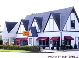
The original Sanders' Cafe, now a museum

The original Sanders\’ Cafe, now a museum

688 US Hwy 25 W
Corbin, KY

While driving I-75 en route to Disneyworld, Disboards user ‘Disney Janet’ (now of Seattle, WA) stumbled upon the original Kentucky Fried Chicken outside of Corbin KY. “There is a little museum there and it was neat and free. It is definitely one of my strongest memories of our drives down to Florida as a kid.” After touring the museum, grab lunch or dinner and continue on your way!

Date last visited: 2003

Distance off the interstate: 5-10 minutes off of I-75.

Hours and Admission Prices: Free to tour museum. Hours are 10 am to 10 pm.

Bathrooms: Yes.

Food Services: That’s what it’s all about at this pitstop!

Website: http://www.corbinkentucky.us/sanderscafe.htm

Directions: Directions: From I-75 take exit 29, go south on 25E one mile, then right on 25w one-half mile. Located at the junction of 25E and 25W in Corbin.

View Larger Map

McArthur Burney Falls State Park

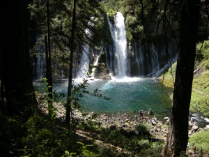
The inviting pool at the base of the falls.

The inviting pool at the base of the falls.

24898 Hwy 89
Burney, CA

McArthur Burney Falls State Park is one of the nicest state parks I’ve run across in a long time. In northern California’s volcanic country near Lassen National Park, it sits directly on Highway 89 near Burney. After you enter the park, you’ll find a large, shaded picnic area to your right, with parking to the left. Follow the signs to the Burney Falls overlook for an amazing view. 129-feet high, Burney Falls is stunning (and dumps 100 million gallons of water a day!). The 0.3 mile walk to the base of the falls is well worth it; at the bottom, enjoy the soft spray or dip your toes in the freezing water. The basin is a beautiful blue. There’s a loop trail to try if time is permitting (1.3 miles), or just retrace your steps back to the top (0.6 round trip). We picnicked at a nearby table, but wished we’d had enough time for a swim in nearby Lake Britton.

Date last visited: July 2009

Distance off the interstate: Located directly on Highway 89, or six miles north of Highway 299.

Admission Prices: $6 per car for day use.

Bathrooms: Located across the street from the day use parking. They looked brand new.

Food Services: A nice general store with all the necessities, plus soft serve ice cream!

Website: http://www.parks.ca.gov/?page_id=455

Directions: Take Highway 89 near Burney. (From Redding, go north on Hwy 299 past Burney and follow signs.)

View Larger Map

Slide Rock State Park

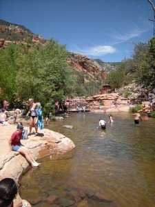
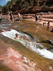
Slide Rock State Park, July 2009

Slide Rock State Park, July 2009

6871 N. Highway 89A
Sedona, Arizona

Slide Rock State Park may be a bit further off the beaten path than most pitstops (18 miles from Flagstaff), but it’s a mere five miles from the popular vacation town of Sedona, and well worth any amount of effort.

Slide Rock State Park planning:

Located down Highway 89A along a particularly scenic stretch of Oak Canyon, Slide Rock State Park is exactly what it professes to be: a slippery, natural waterslide. Upon first sight, my kids were awestruck, and quite frankly, so was I. At least a quarter mile of the river is cut so perfectly out of the red rock canyon, it appears man-made. The water pools and eddies around smoothly rounded slabs of granite, creating both slick slides and deep diving holes.

Nate, sliding down a shute.

Nate, sliding down a shute.

There’s about a quarter mile walk from the parking lot to the swimming site. It’s easy to access, but bring good water shoes. I know this is simply common sense, but the rocks are very, very slippery. We fell many times, and saw worse. There’s very little shade, and not much room on the slabs of stone for chairs. We opted to bring only beach towels and a cooler with cold water, which worked out great. We didn’t spend much time out of the water, anyway!

Date last visited: July 2009

Distance off the interstate: 18 miles off I-17 on Hwy 89A from Flagstaff; five miles from Sedona.

Hours and Admission Prices: Slide Rock is a state park, and entry is $10 per car or $2 per person. Hours are sunrise to sunset, but be advised: the park becomes very crowded on hot summer days, and when the parking lot fills, the park is closed. We visited on a Tuesday in July, and were one of the last cars admitted at 11 am. Get there early!

Bathrooms: Near the parking lot.

Food Services: There is a small general store located near a historic homestead en route to the slide (after the parking lot). It was well-stocked with cold drinks, ice cream, and snacks, but don’t plan to get a full lunch here.

Website: http://azstateparks.com/Parks/SLRO/

Directions: From Sedona: Head north on AZ-179 toward Sombart Ln. Turn left to stay on AZ-179, then turn right at N Hwy-89A/AZ-89A.

From Flagstaff: Take AZ-89 toward Sedona. Turn left at S Hwy-89A/AZ-89A. Turn left at N Hwy-89A/AZ-89A.


View Larger Map

Bassetts Station

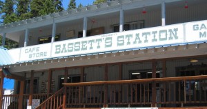
Bassetts Station, CA

Bassetts Station, CA

100 Gold Lake Road
Sierra City, CA

Once a stagecoach stop, Bassetts Station is still a much-appreciated rest stop for travelers navigating US Hwy 49’s windy, tree-lined turns. Serving both campers, fishermen, and hikers in summer and snowmobilers in winter, Bassett’s sits conveniently at the junction between several prime locations for outdoor recreation, and provides all the conveniences of home: gas (both unleaded and diesel), a well-stocked store, a cafe, firewood, even sandwiches and ice cream. There’s a motel as well (although we stayed just a mile or so further down Gold Lake Road at Salmon Creek Campground, which we loved. If you need nothing else, stand on Bassett’s wooden porch and take in the breathtaking view of the Sierra Buttes and surrounding Sierra Nevada Mountain Range.

If you have time (or are headed further down 49 anyway), make another stop in the town of Downieville. From the Sierra County Visitor’s Guide: “Visit the historic gallows outside of the courthouse, the see Sierra County’s collection of gold nuggets in the lobby. Walk through the historic county seat, wander the shops on Main Street, laze at “The Forks” of the North Yuba and Downie rivers, and grab a copy of California’s oldest weekly newspaper.”

Also worth visiting, the Downieville Museum is open through the summer months and on many weekends through the spring and fall. Learn all about the gold rush which once made this tiny community a boom town. Located in a stone building on Main Street.

Date last visited: July 2009

Distance off the interstate: Bassett’s is directly at the junction of 49 and Gold Lake Road. Downieville is another approximate 20 miles.

Bathrooms: Yes.

Food Services: Grab a burger at Bassett’s and eat it outside in the alpine air.

Website: None.

Directions: From Sacramento: Take I-80 E to Exit 188A toward Truckee. Turn left at Donner Pass Rd. At the traffic circle, take the 3rd exit onto CA-89/State Route 89. Continue to follow CA-89, then turn left at CA-49/CA-89/W Main St. Continue to follow CA-49. Destination will be on the right.

From Reno, Nevada: Take the ramp onto I-80 W, entering California. Take exit 188 for CA-267/CA-89 toward Lake Tahoe, then turn right at CA-89/State Route 89 (signs for Truckee/CA-89/Loyalton). At the traffic circle, take the 2nd exit and stay on CA-89/State Route 89. Continue to follow CA-89 to CA-49.
View Larger Map

Tallahassee Museum with kids

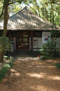
Discovery Center at the Tallahassee Museum

Discovery Center at the Tallahassee Museum

3945 Museum Drive
Tallahassee, FL

The Tallahassee Museum is located on I-10 mid-way between Pensacola and Jacksonville. Says Lucia of Dim Sum, Bagels and Crawfish, We drive I-10 between Florida and Louisiana on a pretty regular basis and each time we drive through Tallahassee I see the signs for the Tallahassee Museum. I often wonder about it and make a mental note to stop on a future trip. Well, last weekend on the way back from a week at the beach my mom and my son turned it into a memorable pit stop. They kept raving about all of the interesting animals they saw. My mom was especially impressed with the cypress lake and the fact that most of the paths are well shaded (very important and not always easy to find on hot Southern days). In addition to the outdoor exhibits, there are also some interesting hands-on displays inside.

For a map and more positive reviews on the Tallahassee Museum, check here.

Date last visited: July 2009

Distance off the interstate: Ten minutes from the I-10 exit (well marked with sign for the museum).

Hours and Admission Prices: 9 a.m. – 5 p.m. Monday-Saturday and 12:30 p.m.  5 p.m. Sunday. Entry fees are $9.00 for adults and $6.00 for children, per their official website.

Bathrooms: Yes.

Food Services: A quick service cafe with kids’ meals.

Website: http://tallahasseemuseum.org

Directions: Take exit 196 for FL-263. Keep left at the fork, follow signs for Tallahassee. Turn left at Capital Circle NW/FL-263, then left W. Orange Ave. Turn right at Rankin Ave. Rankin Ave becomes Museum Dr.


E.J. Roberts Park

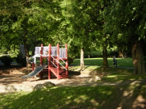
Shady and green playground in E.J. Roberts Park

Shady and green playground in E.J. Roberts Park

North Bend
Washington

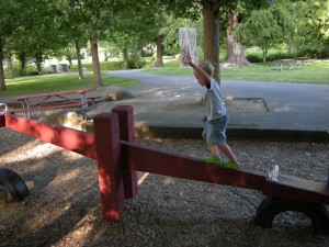
If you’re stopping for a quick bite to eat in North Bend, WA, you’ll quickly lament the lack of play lands at any of the fast food offerings. But a quick inquiry of the drive thru staff at Taco Time led us to E.J. Roberts Park. Only a few minutes into town (and it’s a lovely town!), EJ Roberts is a beautiful little respite from a long roadtrip. Located in a quiet residential area, the park is medium-sized, with a shaded play area, lots of grass to throw a ball around, and picnic tables, all with a stunning mountain backdrop.

Toby, engage in horseplay? Noooo....

Toby, engage in horseplay? Noooo….

Date last visited: June 2009

Distance off the interstate: Three minutes off I-90.

Bathrooms: They were not very clean, but frankly, we were just glad they were there!

Food Services: Plenty of fast food nearby, including McDonald’s, Taco Time, and KFC. There’s also a Safeway within five minutes.

Directions: From I-90, take Bendigo Blvd to E. 4th, then turn left on Ballarat. Turn right on SE 114th, which turns into 6th. Park is on the right.

For more travel photos today, check out Photo Friday at delicousbaby.com.
View Larger Map

La Tarasca Restaurant

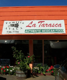
La Tarasca in Centralia, WA

1001 W. Main
Centralia, WA

All the other reviews out there are right: La Tarasca has excellent Mexican food¦perhaps the best, and certainly the most authentic, I’ve ever tasted. Due to its close proximity to The Great Wolf Lodge Grand Mound, this restaurant has been heavily reviewed (just do a Google search), but all those words really do bear repeating. From the street, the place is nothing to look at, but don’t let that dissuade you. Inside, it’s colorful and cheery. We were served by the restaurant’s owner herself, who was happy to help us decide which of her native southern Mexican specialties we’d most enjoy. When our four-year-old couldn’t decide on his drink order, she told him she’d whip him up something special’ and came back with a delicious rice milk and cinnamon concoction. The restaurant does has a children’s menu, but she allowed mine to customize it to their tastes (my ten-year-old substituted beans for meat in his taco, for instance, and my seven-year-old opted for a tamale hot out of the oven instead of any of the kid offerings). My husband ordered carnitas (the house specialty), and ended up sharing his plate with all the kids, who all loved it (which is rare, as they’re primarily vegetarians). I ordered the chile relleno, and can say it’s the best I’ve ever had.

Date last visited: June 2009

Distance off the interstate: About two minutes.

Bathrooms: Yes.

Website: None. There is a phone number however: 360-736-7756. It’s advisable to call to check hours, which can vary. At the time of this posting, it’s open until 9 pm, and is closed every Tuesday.

Directions: From I-5, take Exit 82 (Harrison Ave). After Yew Street, Harrison turns into Main. The restaurant is located on the left.
View Larger Map