Sunset Bay State Park

Sunset Bay State Park on Oregon’s beautiful scenic coast is one of our family’s favorite destinations. Situated between the tourist hot spots of Bandon to the south and Cannon Beach to the north, it works as a wonderful pit stop along Hwy 101, whether for a picnic, a whole afternoon, or an overnight (or two).

sunset-bay-yurt

If you plan to stay only a short while, park at the picnic/group camping area and enjoy one of the most scenic beaches on the pacific coast. Explore the tide pools if you’ve timed your arrival right, or let your kids play on the huge pieces of driftwood or run along the sand. If they (or you!) are daring (or just crazy like my kids), take a dip in the cold Pacific. If time permits, take the Oregon Coast Trail right from the beach to Cape Arago State Park to see their stunning gardens over the ocean (4 miles). If you want a shorter hike, follow the signs from the mouth of big creek to the viewpoint overlooking Sunset Bay (1/2 mile).

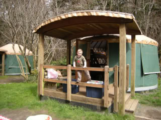
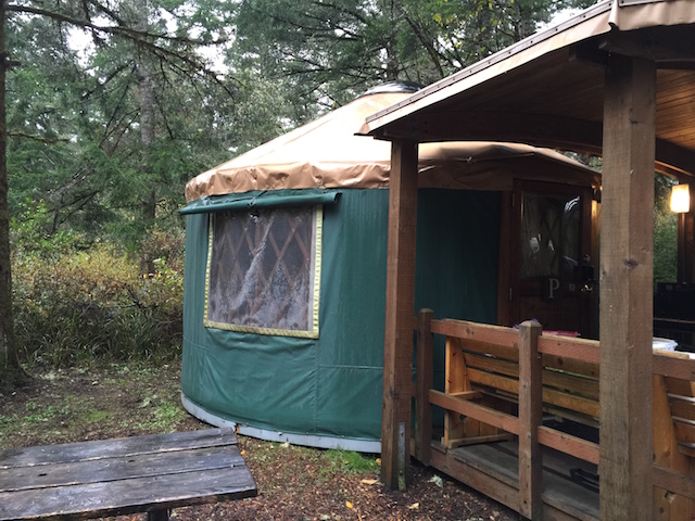
If you’re staying overnight, consider booking a yurt. Oregon state parks are well-known for these unique accommodations. One part tent and one part hut, state park yurts are heated, wired with electricity, and come furnished with comfortable bunkbeds (sleeps 5 easily), a table and chairs, coat pegs, and covered porches.

We’re not usually campground campers (preferring to backpack far from the crowds) but given coastal Oregon’s lush landscape, the sites felt very private (and the yurts are located on their own loop). Hint: come in the off-season when prices drop and the campground is nearly a ghost town! You’ll have the run of the place! Read more about our yurt adventures!

yurt-exterior

Distance off the interstate: 15 minutes from Hwy 101.

Date Last Visited: November 2009

Hours and Admission Prices: Day visitors pay only $4 per car. Open sunrise to sunset. Nightly camping fees range from $12 for a tent camp site to $27 for a yurt in the off-season to $19 for a tent site to $36 for a yurt in the peak season (starting May 1st). Full RV hookup sites are available as well. To book, start at Oregon State Parks.

Bathrooms: All very clean, well-lit, and heated. While we visited in the off-season, there were no lines for showers and plenty of hot water.

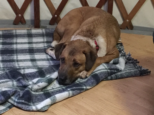
Dogs: Select yurts are dog-friendly (as is the case in most Oregon coast state parks). Check for the dog-friendly ‘paw print’ when reserving your yurt online.

dog-friendly-yurt

Food Services: None at the state park. You’ll want to stock up on supplies in nearby Coos Bay (10 miles), where you can find a Fred Meyer or Charleston (no major grocery stores, but a few decent mini-marts). Coos Bay also has fast food and casual dining.

Directions: From Oregon Coast Hwy/US-101, take the 1st left onto W Beaver Hill Rd, then a slight right at 7 Devils Rd. After six miles, turn left at Walker Ave, then take a slight left at Cape Arago Hwy. Stay on Cape Arago Hwy for 2.5 miles, and the state park will be on the left.

Sunset Bay State Park

High Falls State Park with kids

High Falls (photo courtesy of Georgia State Parks)

High Falls (photo courtesy of Georgia State Parks)

76 High Falls Park Dr
Jackson, GA

Mondays are for dreaming, and today, I’m dreaming of being out-of-doors, enjoying autumn sunshine! Late fall can provide some of the best hiking and nature walking, and if you’re living in or driving through Georgia on I-75, High Falls State Park is a beautiful place to stop and explore for an afternoon or an entire weekend!

High Falls State Park with kids:

Hike the 4.5 miles of trails, visit the waterfall on the Towaliga River, and explore the site of a grist mill (in the remains of a ghost town). High Falls also boosts a lake, picnic shelters, boating, and fishing. Canoe rentals are also available.

Throughout the month of November, check Georgia State Parks’ Leaf Watch guide (and for your summer visits, remember that there’s a seasonal swimming pool as well)!

There’s also plenty of tent, trailer, and RV camping, but if you think it’s too cold to camp this last in the season, think again! With beautiful rustic yurts, traditional camping can be extended all year long! (As you may know, I’m a big fan of yurts!)

Distance off the interstate: One mile off I-75

Hours and Admission Prices: Daytime parking fee is $5 per car. If you’re interested in visiting one of Georgia’s other state parks, such as Red Top Mountain, lodge rates have been reduced significantly for the off-season! Find a room here: http://gastateparks.org/core/item/page.aspx?s=171331.0.1.5&mode=h

Food Services: Says Georgia State Parks Public Affairs Coordinator Kim Hatcher, There’s a great Southern restaurant one exit north (Buckner’s) with some of the best fried chicken in Georgia!

Website: http://www.gastateparks.org/info/highfall/

Directions: From I-75, take Exit 198 at High Falls and go 1.8 miles east on High Falls Road.

This pit stop submitted by Kim Hatcher. Thank you, Kim! I’m always happy to promote the beauty of state parks!

Red Top Mountain State Park

Boy holding a pumpkin

50 Lodge Road SE
Cartersville, GA

Autumn is officially upon us here in the northern hemisphere, and I’m very excited to kick off a new series of pit stops centered around fall festivals and events with Red Top Mountain State Park’s Fall at the Homestead! Located just one mile off I-75 on beautiful Lake Allatoona, there’s no better time to visit Red Top Mountain State Park than this weekend (September 26-27). Not only will you have the opportunity to take part in their autumn festival, but you’ll park for free! This Saturday only, all Georgia state parks are waving their parking/vehicle fee.

A hiking trail in Red Top Mountain State Park in autumn.

A hiking trail in Red Top Mountain State Park in autumn.

More on Fall at the Homestead (Sept. 26-27):

From the official website of Georgia state parks: Step back to the early 1800s with a visit to Vaughn Cabin to learn about pioneer life. Try your hand at candle dipping and woodworking, or play a few games. On Saturday night, we will fire up a large furnace for the always popular iron pour. Come early to buy scratch blocks to design your own keepsake. We’ll fill it with molten iron, and once it cools late that evening, you can take it home. ($7 scratch blocks for iron pour.)

While you’re visiting, be sure to take advantage of the many hiking trails and the swimming beach Red Top Mountain State Park has to offer!

Distance off the interstate: 1.5 miles from I-75 exit 285.

Hours and Admission Prices: Free parking on Saturday, September 26th. $5 parking on Sunday.

Bathrooms: Yes.

Food Services: Many picnic shelters are located along the lake shore as well as a restaurant located within the lodge. The Mountain Cove Restaurant is open year-round and serves buffet and a la carte meals for breakfast, lunch and dinner.

Website: www.GaStateParks.org/redtopmountain

Directions: From Atlanta, take GA-401 N/I-75 N for 37 miles, then take Exit 285 for Red Top Mountain Road. Follow for .3 mile, the keep right at the fork to merge onto Red Top Mountain Rd SE.

Thank you to Kim Hatcher, Public Affairs Coordinator of Georgia State Parks & Historic Sites for providing the information on this event! 
View Larger Map

Reed Bingham State Park

542 Reed Bingham Road
Adel , GA

Not quite ready to let go of summer? Reed Bingham State Park “is about three and a half hours from Atlanta…if camping isn’t your thing, it’s also a good place to just get off the road for a bit to stretch your legs, enjoy a picnic or even squeeze in a game of mini-golf. In addition to mini-golf, Reed Bingham has a nice playground, beach and boat docks. They also rent bicycles and canoes and offer pontoon boat tours. It’s an excellent place for bird watching or learning more about the resident gopher tortoises. The park staff rehabilitates various animals that are orphaned or left on the property. We were lucky enough to see a hummingbird, bluebird, red-headed woodpecker and even a bobcat kitten!”

Review courtesy of Sue from Field Trips with Sue.

Date last visited: August 2009

Distance off the interstate: Less than 6 miles off I-75.

Hours and Admission Prices: $5 park entrance fee per car (camping fees start at $23)

Website: Reed Bingham State Park

Directions: 6 miles west of Adel on Ga. Hwy. 37 via I-75 exit #39, and 14 miles east of Moultrie from U.S. Hwy. 319.

Alfred B. Maclay Gardens State Park

Brick path leading to the Maclay house. Photo courtesy of Florida State Parks.

Brick path leading to the Maclay house. Photo courtesy of Florida State Parks.

3540 Thomasville Rd
Tallahassee, FL

Alfred B. Maclay Gardens State Park is a wonderful place to get out and stretch your legs during a long trip. During blooming season, flowers paint the walk with beautiful colors and during the off season you can see every shade of green, says Jennifer of Two Kids and a Map, who brings us this review. I was on a road trip from Pensacola to Jacksonville, Florida with my two children by myself and we desperately needed a pit stop! The kids were getting hungry and anxious and I was tired of listening to the whining. Unfortunately, the exit I chose is awful for quick interstate stops. There are several lanes of traffic and it is difficult to turn around to get back on the Interstate. I spotted the trademark Florida State Park sign and followed it to the entrance. It was a perfect stopping place for us. The children got to run along the path of the gardens and burn off some steam. There was so much to look at: a hidden garden, a lake and a pond, and the beautiful home. The kids enjoyed looking for bugs and eating a picnic lunch on the grounds before we got back on the road.

Date last visited: July, 2009

Distance off the interstate: Approximately 1 half mile off of Interstate 10.

Hours and Admission Prices: $6.00 per vehicle to enter the park. During the blooming months, it is an additional $6.00 an adult and $3.00 a child to enter the gardens. However, during the off season (May through December) touring the gardens is free.

Bathrooms and Food Services: Bathrooms are available and there are picnic areas if you bring your own meal

Other tips: Be sure to get your Real Florida Passport stamped while you are there. You can walk down to the house and back in about 30 minutes if you do not stop too many times!

Website: http://www.floridastateparks.org/MACLAYGARDENS/

Directions: Located one half mile north of I-10 on U.S. 319
View Larger Map

McArthur Burney Falls State Park

The inviting pool at the base of the falls.

The inviting pool at the base of the falls.

24898 Hwy 89
Burney, CA

McArthur Burney Falls State Park is one of the nicest state parks I’ve run across in a long time. In northern California’s volcanic country near Lassen National Park, it sits directly on Highway 89 near Burney. After you enter the park, you’ll find a large, shaded picnic area to your right, with parking to the left. Follow the signs to the Burney Falls overlook for an amazing view. 129-feet high, Burney Falls is stunning (and dumps 100 million gallons of water a day!). The 0.3 mile walk to the base of the falls is well worth it; at the bottom, enjoy the soft spray or dip your toes in the freezing water. The basin is a beautiful blue. There’s a loop trail to try if time is permitting (1.3 miles), or just retrace your steps back to the top (0.6 round trip). We picnicked at a nearby table, but wished we’d had enough time for a swim in nearby Lake Britton.

Date last visited: July 2009

Distance off the interstate: Located directly on Highway 89, or six miles north of Highway 299.

Admission Prices: $6 per car for day use.

Bathrooms: Located across the street from the day use parking. They looked brand new.

Food Services: A nice general store with all the necessities, plus soft serve ice cream!

Website: http://www.parks.ca.gov/?page_id=455

Directions: Take Highway 89 near Burney. (From Redding, go north on Hwy 299 past Burney and follow signs.)

View Larger Map

Slide Rock State Park

Slide Rock State Park, July 2009

Slide Rock State Park, July 2009

6871 N. Highway 89A
Sedona, Arizona

Slide Rock State Park may be a bit further off the beaten path than most pitstops (18 miles from Flagstaff), but it’s a mere five miles from the popular vacation town of Sedona, and well worth any amount of effort.

Slide Rock State Park planning:

Located down Highway 89A along a particularly scenic stretch of Oak Canyon, Slide Rock State Park is exactly what it professes to be: a slippery, natural waterslide. Upon first sight, my kids were awestruck, and quite frankly, so was I. At least a quarter mile of the river is cut so perfectly out of the red rock canyon, it appears man-made. The water pools and eddies around smoothly rounded slabs of granite, creating both slick slides and deep diving holes.

Nate, sliding down a shute.

Nate, sliding down a shute.

There’s about a quarter mile walk from the parking lot to the swimming site. It’s easy to access, but bring good water shoes. I know this is simply common sense, but the rocks are very, very slippery. We fell many times, and saw worse. There’s very little shade, and not much room on the slabs of stone for chairs. We opted to bring only beach towels and a cooler with cold water, which worked out great. We didn’t spend much time out of the water, anyway!

Date last visited: July 2009

Distance off the interstate: 18 miles off I-17 on Hwy 89A from Flagstaff; five miles from Sedona.

Hours and Admission Prices: Slide Rock is a state park, and entry is $10 per car or $2 per person. Hours are sunrise to sunset, but be advised: the park becomes very crowded on hot summer days, and when the parking lot fills, the park is closed. We visited on a Tuesday in July, and were one of the last cars admitted at 11 am. Get there early!

Bathrooms: Near the parking lot.

Food Services: There is a small general store located near a historic homestead en route to the slide (after the parking lot). It was well-stocked with cold drinks, ice cream, and snacks, but don’t plan to get a full lunch here.

Website: http://azstateparks.com/Parks/SLRO/

Directions: From Sedona: Head north on AZ-179 toward Sombart Ln. Turn left to stay on AZ-179, then turn right at N Hwy-89A/AZ-89A.

From Flagstaff: Take AZ-89 toward Sedona. Turn left at S Hwy-89A/AZ-89A. Turn left at N Hwy-89A/AZ-89A.


View Larger Map